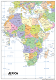
Africa Political Map
Tax included.
A bright and colourful political map for the wall or desktop. Ideal for either hanging on the wall as a display or for educational purposes.
Laminated option: Printed onto quality paper and finished with a gloss laminate.
Vinyl option: Printed onto heavy weight vinyl with metal eyelets for easy hanging. The material is very durable and hard wearing and can also be rolled up for storage and wiped clean
Africa contains 54 fully recognised sovereign states (countries):
- Algeria
- Angola
- Benin
- Botswana
- Burkina Faso
- Burundi
- Cameroon
- Cape Verde
- Central African Republic
- Chad
- Comoros
- Democratic Republic of the Congo
- Republic of the Congo
- Djibouti
- Egypt
- Equatorial Guinea
- Eritrea
- Eswatini
- Ethiopia
- Gabon
- Gambia
- Ghana
- Guinea
- Guinea-Bissau
- Ivory Coast
- Kenya
- Lesotho
- Liberia
- Libya
- Madagascar
- Malawi
- Mali
- Mauritania
- Mauritius
- Morocco
- Mozambique
- Namibia
- Niger
- Nigeria
- Rwanda
- Senegal
- Sao Tome and Principe
- Seychelles
- Sierra Leone
- Somalia
- South Africa
- South Sudan
- Sudan
- Tanzania
- Togo
- Tunisia
- Uganda
- Zambia
- Zimbabwe
- Sahrawi Arab Democratic Republic
- Somaliland


