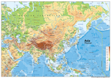
Asia Physical Map
A colourful map of Asia showing physical features. A fantastic resource for the classroom or home, perfect for geographical studies. Asia is Earth's largest and most populated continent, covering an area of 44,579,000 square kilometres, about 30% of Earth's total land area and 8.7% of the Earth's total surface area. The continent was the site of many of the first civilizations. Asia is notable for not only its overall large size and population (about 60% of the world's population), but also dense and large settlements, as well as vast barely populated regions.
In general terms, Asia is bounded the Pacific Ocean on the east, on the south by the Indian Ocean, and on the north by the Arctic Ocean.
The map is available in various sizes and materials:
Paper Laminated - Printed on paper which is then finished with a durable gloss laminate.
Vinyl - Printed on hard-wearing, heavy-weight vinyl banner, provided with metal eyelets in the corners.
Mounted Board - Printed on a rigid plastic board using stay-fast, waterproof inks. Includes holes and fixings. Please note - mounted maps require extra handling time (approx 14 days).
There are 48 countries in Asia, according to the United Nations. Listed from the most populated to the least, these are:
1 China
2 India
3 Indonesia
4 Pakistan
5 Bangladesh
6 Japan
7 Philippines
8 Vietnam
9 Turkey
10 Iran
11 Thailand
12 Myanmar
13 South Korea
14 Iraq
15 Afghanistan
16 Saudi Arabia
17 Uzbekistan
18 Malaysia
19 Yemen
20 Nepal
21 North Korea
22 Sri Lanka
23 Kazakhstan
24 Syria
25 Cambodia
26 Jordan
27 Azerbaijan
28 United Arab Emirates
29 Tajikistan
30 Israel
31 Laos
32 Lebanon
33 Kyrgyzstan
34 Turkmenistan
35 Singapore
36 Oman
37 State of Palestine
38 Kuwait
39 Georgia
40 Mongolia
41 Armenia
42 Qatar
43 Bahrain
44 Timor-Leste
45 Cyprus
46 Bhutan
47 Maldives
48 Brunei
Dependencies or other territories
1 Taiwan
2 Hong Kong
3 Macao


